Southern Tier Part 3 - Day #7 Globe, AZ to Sycamore Creektrail, AZ
Southern Tier Part 3 - Day #7
May 31, 2023
Globe, AZ - Sycamore Creektrail, AZ 81 Miles
Start 5:59 AM Finish 7:49 PM
Total Duration 13:50
Moving Time 7:21
Stopped Time 6:29
Ascent 5328'
Descent 6200'
Tour Total 558 Miles
Details at: https://ridewithgps.com/trips/123058831
I slept well stealth camping at the dusty Southeast Wash, off to the side of Highway 188 east of Globe. Last night in my tent I hopelessly tried to upload my stats with one bar, and finally gave up. I woke up at exactly 5:20 AM as was now the norm. I could hear occasional motor traffic throughout the night and again this morning as I was packing. I had been somewhat visible from the road. Last night I covered my headlamp every time a car passed. This morning as I was packing, a freight train came through and blew its horn. It was a slow pack up in the fine brown dust, and I rode back to the fence for breakfast on the other side. My bike shorts didn’t get caught on the chain link crossing this morning like last night. I had my Starbucks Frappuccino and Hostess Donettes on the asphalt, which I quickly realized was crawling with ants. They started climbing all over me, and I was covered with dust and dirt. I was pretty grimy and in serious need of a shower and clean clothes. My phone was down to 38% from trying to upload stats last night. I took a left on State Highway 188, aka 'The Apache Trail'. The air was chilly and I stopped to put on my gilet. I was headed north up a verdant valley. All of the scrub and grass were lush.
I passed the junction with an unnamed road that also wasn’t listed on my map. Motor traffic on the highway this morning was sparse. I entered Tonto National Forest and cactus began to appear everywhere. Rather than making a straight line to Phoenix on US 60, the route jutted north. There was a mountain range to the west and I had heard something about a tunnel on US 60, which I would be avoiding. The scenery was beautiful with cactus and scrub, and jagged mountains in the distance.
I passed a bunch of tanks in the valley below, and some kind of water filtration plant. I was guessing that it was linked to mining. I later saw that there was a ginormous open pit copper mine directly to the west. I came around a curve and saw 'Road Work Ahead' signs and a pick-up truck with flashing lights. I was beginning the morning climb, and was listening to a fresh Duane Train program from 2/10/2021.
There was a sign warning that ice may be present on the roadway. Orange pylons were positioned down the center of the highway. I came to a construction vehicle and three workers standing in the middle of the road. I removed an earbud and shouted, 'Good Morning!'. Only one of them replied. They were just standing there.
The orange pylons and traces of construction soon ended. I was getting hot on the climb, and stopped to remove my gilet. I kept climbing. As I neared the summit I noticed a brake check area for trucks. A father and his daughter were on the other side of the road walking their two dogs. I went up over the crest and saw a downhill sign with the truck on the triangle. The elevation was 3883'.
A ginormous valley opened up ahead with Roosevelt Lake in the distance. My brim was flopping around in the wind and I couldn't glance back and forth between my gps and the road. A sign read six percent downhill for the next four miles. I was speeding thirty-four miles an hour. I came to a junction with State Highway 288. All of a sudden my brim went flying off my helmet. I had to turn around and pedal a couple hundred feet back to retrieve it. I passed a sign that read Roosevelt four miles, Highway 88 Junction fourteen miles.
A bug slammed into my face right below my left eye directly below my sunglasses. It was a sensitive part of my face and really hurt. It was 7:42 AM and I could see Roosevelt in the distance. My fingers were crossed that a service would be open. In addition I was carrying the empty six pack and coffee bottles which I needed to dispose of. I didn’t pedal for the longest time. There was no point if I was coasting at over twenty miles an hour. I entered Roosevelt, no population listed, and crossed over Pinto Creek.
The Dam Grill and Chill was closed, but a gas station and the Spring Creek Store was open. I purchased a thirty-two ounce Tropicana orange juice and a Jimmy Dean, ham, egg and cheese on a muffin. I bought some postcards and used the toilet where I took a birdbath ion the sink. My phone was down to 25% and I had no service.
I saw a sign for Payson fifty-nine miles, but didn’t see the town on my paper map. I came to a pink section of tarmac with wide tar marks that reminded me of abstract asemic painting. I could see the Tonto Upper Cliff Dwelling from the highway. There was a turn off with an information sign that I stopped to read. The trail up to the dwellings was a mile with no tree cover, and I elected not to visit. My phone battery was dying and I plugged it into my charger. I passed the turn-off for the Windy Hill recreation site.
I entered the Tonto Cliff Dwellings National Monument, and skipped the visitor center. Because of the scorching heat this time of year, nobody was here visiting. I finally descended down to the lake and rode over a bridge. The water level seemed high, and I noticed submerged trees and bushes. I passed a gas station and store with a sign that read 'Bikers Welcome!', and I decided to keep going. There were dozens of houseboats and smaller boats docked in the lake, and I could see someone jet skiing.
I came to the junction with State Highway 88 and crossed the steel arch Roosevelt Bridge. I stopped and took a photo of the Theodore Roosevelt Dam across the Salt River. At the bridge I crossed through a tiny slice of Maricopa County, and stopped to read a road sign about the Arizona Trail.
There was a car parked at Bachelor Cove and a boat out in the water. Very few people were here today. I stopped to put on my filthy arm protectors and to drink some ice cold water. As I wound my way around the lake, I could see Tonto Basin twelve miles ahead in the distance. I passed 3 Bar Road to my left and a Recreation area to my right. All of the recreation areas were empty. I was honked at by a motor vehicle towing a boat. The shoulder was crappy and I was riding just to the left of the white line. I flipped them off in the low position.
I finally crossed over Ash Creek and left the lake behind. I passed the warning sign that read to 'Watch for Animals Next 20 Miles'. Then I got honked at by a white motor vehicle. The shoulder was nothing but rumble strip and cracked pavement. I had no choice but to ride to the left of the white line. I flipped him off with my gesture held high and bold. I pay taxes too dude, and am equally entitled to be here. I crossed over Sycamore Creek.
In Tonto Basin I stopped at the Butcher Hook. I ordered the Green Chili and Eggs over easy with Home Fries, Biscuits and gravy, and a large lemonade. It was one of the best breakfasts I’d had on the tour, and I was able to update my stats. Unfortunately, there was no electrical outlet. I rode through Tonto Basin and passed the RV park, Dollar General, and the Chamber of Commerce. An IGA doubled as an Ace Hardware and gas station. The next town was Punkin Center and I didn’t stop.
I passed a sign that read 'Jake’s Corner 10 miles, Highway 87 13 miles' I would need to make some decisions at Jake’s Corner. I pedaled up a long hill, and at the top was a ginormous cut through the saddle. I crossed Gold Creek.
It was 80°F with thirteen mile-an-hour winds out of the southwest. I had a tail wind. I entered Jake’s Corner and went straight to the Jake's Corner Bar & Grill. It was air-conditioned and dollar bills were plastered to the ceiling. I plugged in my phone and rear light, and ordered a Church Music IPA. I enjoyed the air conditioning and classic rock as I wrote post cards and avoided the outdoor heat. I updated my reports and enjoyed a few more Church Music IPAs. I ordered a bacon cheeseburger with fries and then headed back out into the heat. I rode three and a half miles to State Highway 87 where I took a left going south. It was four lanes divided and headed up into the mountains.
Sunflower was seventeen miles away and Phoenix was seventy-two. I had a fourteen mile-an-hour headwind, and I just kept climbing. There was a wide shoulder, and two massive high-voltage power-lines to my right. I saw a pair of needle-nose pliers laying on the shoulder and had earlier seen a Phillips screwdriver. I’d never forget the cyclist I met on the Trans Am who collected all of the tools that he found alongside the road.
I finally made it to the top of the hill. There were warning signs for the six perecent downhill grade ahead. I sped down the hill and found myself in a deep valley. And then the climbing began again with the wind still blowing straight at me. I passed a wrench and then a pair lineman's pliers. I stopped to mix my air-temperature water with my ice water, and eventually finished all of my cool water. I kept climbing. The thing about hills is they always end. Eventually I saw a warning sign for the approaching downhill and a brake check area.
It was 7 PM and I had ridden seventy miles. It was starting to get cool and I was cresting the second large climb. I reached the 4565' summit, and entered Maricopa county. I stopped to flip my map panel, put on my jacket, and drink some water. I saw a sign that Mesa was forty-nine miles ahead. I crossed kitty Joe Creek, and then Whiskey Springs. The shoulder was in bad shape and filled with debris, so I cautiously rode to the left of the white line. I crossed over Sycamore Creek and noticed a three-quarter moon to the southwest.
I came to Sunflower, no population listed and no services. I had a small climb with a downhill sign up ahead. I saw a sign for Scottsdale forty-eight miles ahead and Phoenix fifty-five. Scottsdale had been peppered out with bullets. I saw a large animal, possibly a wildcat, cross the road ahead. I began a fantastic downhill into a valley with extraordinary scenery. I noticed that the northbound lanes were to my right on an older section of roadway, while I traveled on brand new cast concrete bridge spans to the left.
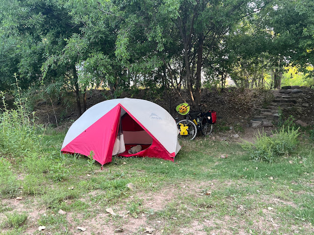
I had ridden eighty miles and had met my goal. I spotted a turn-off, and rode in to check it out. There were dirt tracks on both sides of Sycamore Creek and I erected my tent behind some bushes and next to a ring of rocks from a campfire. There was an adjacent hill with a light beacon that alternated red, blue, and green. The lights seem psychedelic. The colors were fluorescent and didn’t seem government issued. They were enchanting. Inside my tent, I could hear the highway, and I could also hear planes and crickets. I was beginning to have problems with one of my tent zippers. I would eventually need to replace my tent.
 |
| Dusty Southeast Wash where I wild camped |
 |
| Breakfast spot in front of the gate to Southeast Wash |
 |
| Tonto National Forest |
 |
| The Dam Grill and Chill was unfortunately closed |
 |
| Tonto Upper Cliff Dwelling |
 |
| Roosevelt Bridge |
 |
| Theodore Roosevelt Dam |
 |
| Ginormous road cut south of Jake's Corner |
 |
| Tonto National Forest |
 |
| Map / Elevation Profile |

Rob! This is Jason Atkins. it wasn't immediately evident on Strava that you were doing a coast to coast bicycle tour. This really sounds like an adventure. Beautiful pictures.
ReplyDeletePoor shoulder conditions are the bane of our cycling existence. I had a similar experience on a 45mph road this past weekend with poor shoulder conditions - thankfully drivers were accommodating and understanding. May you encounter the same on your journey.