Southern Tier Part 3 - Day #12 Orita, CA to Ocotillo, CA
Southern Tier Part 3 - Day #12
June 5, 2023
Orita, CA - Ocotillo, CA 62 Miles
Start 5:35 AM Finish 1:53 PM
Total Duration 8:18
Moving Time 5:27
Stopped Time 2:50
Ascent 1143'
Descent 744'
Tour Total 958 Miles
Details at: https://ridewithgps.com/trips/123670688
I slept so-so stealth camping in back of the farmhouse near the alfalfa fields alongside California State Highway 78. I was about a quarter-mile off the side of the highway but it was loud. Trucks felt like they were barreling through my tent. It was great to be horizontal and to be cool. I woke up before sunrise and noticed a tractor out in the fields. I quickly got up and started packing. I had leaned my bike against a stack of cut up two inch pipe segments that were organized like firewood. It was a pretty quick pack-up, and I got out of there before anyone noticed. Soon I was pedaling west on the highway. Now that it was daylight, I could see the immense fields of alfalfa and all of the irrigation canals. Further down the road, I passed cornfields. And then I rode by a huge cattle yard that had sunroofs for the poor beasts. Last night as I was trying to fall asleep, I had been inundated by the smell of manure. After Mesquite Cattle Feeders I came to the junction with Highway 115 and continued straight on Highway 78 towards Brawley.
I passed a sign for Brawley seven, Julian eighty-two, and Oceanside a hundred and forty-two - my final destination. I crossed the Alamo River and could see the water tower in Brawley from five miles out. I was a hundred and forty-nine feet below sea level. I passed the San Diego State University Imperial Valley Agricultural Campus and then crossed State Highway 111. Welcome to Brawley, population 26,539, incorporated in 1908, elevation -112'.
I stopped at a Pilot Station and got myself a sausage egg and cheese croissant, and an extra large pink lemonade. I filled my water bottles with ice water and took advantage of the Wi-Fi to upload photos for yesterday's report. I used the bathroom to take a birdbath, and then I headed back out into the sun. I continued a quarter mile further west on State Highway 78, and then I took a left on Old Highway 111.
Old highway 111 paralleled the four-lane motor traffic-packed main highway. There were alfalfa fields to my right, and the wind today was out of the east. My first segment was southbound, and I would later be going west with a tailwind. I crossed over the Highline Canal.
I came to a junction with Imperial County Highway S 27, also known as West Keystone Road. I was a hundred and fifty-six feet below sea level. I passed irrigation equipment and the Mesquite Lake Carroll manure power plant.
I came to the junction with Imperial County Highway, S 28 also known as Worthington Road. I rode past Imperial Valley College and thought about playing in their lawn sprinklers. I could see the water tower in El Centro from three miles out. There were mountain ranges to the south and to the west. It was hazy in the valley today.
I came to the intersection with Evan Hughes Highway which led into El Centro, which was off route. I continued south on old State Highway 111, and could see Interstate 8 in the distance. The area reeked of manure.
I’d been passing billboards that read, 'Burn a bail go to jail'. There were ginormous piles of cargo container-size bales stacked all over the place. I wonder if mischievous knuckleheads were doing the torching or if there was a political motivation. Old Highway 111 ended, and I entered heavily trafficked four-lane State Highway 111, aka Fire Chief F. S. "Pete" Pedroza Memorial Highway. I passed a melon patch to my right
I came to the junction of State Highway 86, and stopped at an Arco station for an extra large Breeze raspberry iced tea with watermelon and cucumber, along with a package of Hostess Donettes. I was listening to a fantastic Duane Train episode from 11/20/19.
The name 'California' comes from the Spanish phrase “hot furnace” caliente horno, and it was living up to its name. I rode down a hill and passed the Mountain View Cemetery. The wrought iron lettered sign was only readable to vehicles traveling north.
Welcome to Calexico 'The International Gateway City', population 38,572, incorporated in 1908, elevation 1'. I crossed the Central Main Canal. The international border was three miles ahead. Riding through Calexico I passed outlet stores and sprawl. Then I crossed the All American Canal.
The turn onto State Highway 98 was a bit harrowing. There was construction and the right turn lane was closed. Motor traffic was heavy, and I rode up against a jersey barrier with cars and trucks following me close behind. Fortunately no one would pass me in the single lane. The construction eventually ended and the shoulder returned. I crossed over some train tracks and was now headed west. Calexico was the closest I’d been to the border since El Paso.
By 10:30 AM I'd ridden thirty-one miles. West from Calexico my next service opportunity would be thirty-three miles away. Calexico probably had better food options than what lied ahead, but the day was still young, and I needed those miles before it got blazing hot.
I passed a sign, 'Jacumba forty-eight, El Cajon one hundred six, San Diego one hundred twenty'. I stopped at a fruit stand and met the proprietor Jesus. He offered me some local dates that were out of this world delicious. If only the containers hadn't been so big. I would have definitely purchased some.
I crossed over the New River, the second New River of the tour, and then I rode by the Imperial County Refuse Site. There were alfalfa fields to the right and a solar farm to the left. I passed over Greeson Wash. To the south, I could see the hideous border wall slashing the edge of a mountain like a scar. Posterity favored the Mountain over the fence. I passed the Mount Signal Café serving Mexican food, which seemed like it had been shuttered for a long time.
I passed miles of solar farms to both sides of the highway. Then I noticed the Mount Signal Solar Power Plant, and a major high-voltage line going west from the farm. I noticed a white border patrol pick-up truck, and then the junction for Imperial County S 29 towards Seeley, and then I crossed over the Wormwood Canal. Following that was the West Side Main Canal. Then I saw two more border control agents with some sort of electronic apparatus on a mast.
There was a large Grove of palm trees at Tom’s Hayfield, and then I crossed under major three major high-voltage power lines heading west. I had filled up my water bottles with ice water this morning at the truck stop. By 11:30 AM only the insulated bottle was still cold. The others were 90°F like tea. The landscape was barren with dirt, rocks, and scrub. I was riding through the Yuha desert.
I noticed that I was at a hundred and three feet elevation and back above sea level again. My plan was to do some climbing this afternoon to begin crossing the coastal range. At noon I was sixteen miles away from Interstate 8. I had ridden forty-seven miles.
I noticed a two-wheel vehicle coming towards me in the oncoming lane on the shoulder. He was on a motor scooter, and a little while later after making a U-turn he pulled up besides me. His name was Alex Gonzalez, and he was going to Mexicali. He had traveled all over the world and showed me a picture of himself with the Pope and another of himself standing on the Great Wall. You never know who you’re going to run into out in the middle of nowhere.
There was a white flashing beacon that I could see for miles. When I got closer I realized that it was some kind of surveillance tower. I passed Sunrise Butte, which was really more of a mound. It had some sort of structure and cross on top of it, and there was a sign that read, 'Oasis'. I could see the border wall, which dead-ended into a mountain.
I could see a wind farm ahead up in the mountains. I passed the turn-off for Custom S Road. Coyote Two dirt track went up into the mountains towards the border. The highway curved around the mountain range towards the valley where I could see another wind farm. There were communication towers running along the highway. Wind farms can be a sign of trouble when you're on a bike tour and, sure enough, I had a ferocious headwind. I had to pedal down the hill into the valley.
I stopped to drink some cold water from my insulated bottle, and displaced what I had drank with hot water. My next water stop wouldn’t be as enjoyable. I passed the Juan Bautista de Anza National Historic trail to my right, and Coyote 1 dirt track to my left. The road turned and I was now facing a ridiculously strong headwind. I could see Interstate 8 in the distance.
As I got closer to Ocotillo I noticed abandoned empty ranches, old vehicles and farm equipment. A little closer to town I saw trailers with American flags billowing in the wind. The gusts were ridiculous. I was using my lowest gears, and could barely make any headway. I could see a Chevron station in the distance and it took me forever to get to the turn-off. My last two miles were the most difficult and I finally made it to the junction with County Highway S 2, aka the Imperial Highway, towards Ocotillo.
At the sharp turn I now had a tailwind and went flying down the road. I felt like I might be carried up into the air, and it was difficult maintaining control of the bike. At the Chevron, there wasn’t much of a selection, and I got a strawberry melon Brisk and a bottle of water. I asked the proprietor if there was a restaurant in town, and he mentioned a cafe a few blocks past the Interstate. He told me that the wind would probably blow all night long.
I flew down the road and went to the Red Feather Off-Road Market & Cafe where I ordered a cheeseburger, fries, and lemonade. Everyone was talking about the wind and folks were wondering why all the windmills weren't working. A wind farm technician came into the establishment, and explained that the turbines would go off line if the wind was above fifty miles per hour. He said the forecast called for high wing gusts all night and tomorrow. He told me that the wind would get even worse going over the pass. My Windy app forecast a break tomorrow morning. It appeared I'd be spending the night here.
I met hiker Kim, trail name 'Tough Love' from New Haven Connecticut. She had a rental car and offered me a ride over the pass. As tempting as the offer was, I couldn't allow a gap. I sat inside at a table and edited this report while the employees cleaned the restaurant. They closed at 4 PM and said that I could camp out back. There was an electrical outlet and a water spigot. The wind was out of control, and nobody had ever seen it this crazy. I met another hiker whom had just arrived in a van with Colorado plates. He lived in Telluride and was originally from Louisville Kentucky. He had come from Arizona and had seen Tough Love's name in the guest books. He told me that it was difficult driving in the wind and that it was diminishing his gas mileage. We would have spoken longer, but the wind gusts were whipping dust, dirt, and sand.
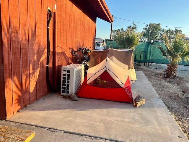
I set up my tent on a concrete slab right behind the cafe, and had to use large rocks in the corners to prevent it from blowing away. It was still light when I crawled inside and went to sleep.
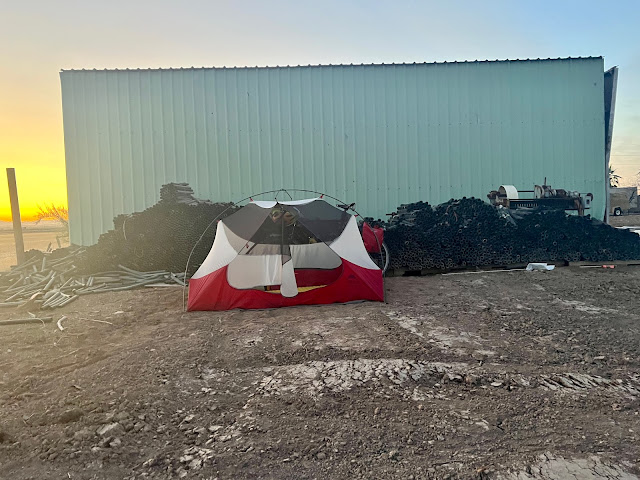 |
| Stealth camping behind a shed alongside California State Highway 78 |
 |
| Irrigation canal alongside California State Highway 78 |
 |
| Imperial Valley, CA |
 |
| Stinky Mesquite Cattle Feeders |
 |
| Ugh |
 |
| Haystack fires |
 |
| Trying to stay hydrated and energized |
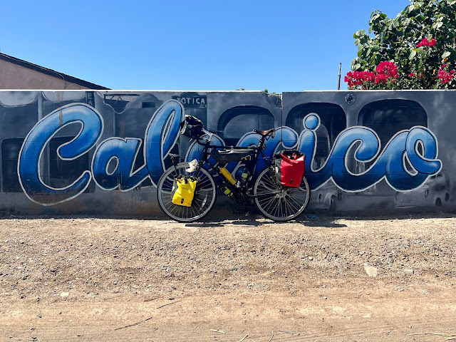 |
| Calexico, CA |
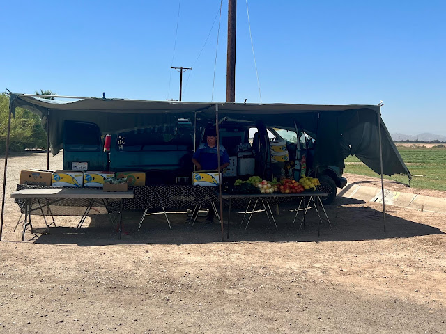 |
| Fruit stand with amazing dates |
 |
| Tom’s Hayfield |
 |
| High voltage lines heading to the coast |
 |
| Alex Gonzalez on his way to Mexicali |
 |
| Map / Elevation Profile |
Comments
Post a Comment