Southern Tier Part 3 - Day #9 Phoenix, AZ to Wickenburg, AZ
Southern Tier Part 3 - Day #9
June 2, 2023
Phoenix, AZ - Wickenburg, AZ 80 Miles
Start 7:00 AM Finish 7:53 PM
Total Duration 12:53
Moving Time 7:07
Stopped Time 5:46
Ascent 2782'
Descent 1329'
Tour Total 710 Miles
Details at: https://ridewithgps.com/trips/123309072
I slept well in room # 241 at the Hampton Inn Biltmore in Phoenix. The air conditioner had a mind of its own and the room fluctuated between hot and cold. It was never just right. Breakfast service began at 6 AM and I set my alarm for 5:45. I got up, folded my laundry, packed, and cleaned my chain. My devices were fully charged and I was back at level one. I had a great breakfast with scrambled eggs, bacon, sausage slices, and home fried potatoes, along with two bowls of Kellogg’s Krave chocolate cereal and several glasses of cranberry juice. While sitting there in the breakfast area, I realized that yesterday I had forgotten to use the pool.
Phoenix is a flat horizontal city, spreading out like a checkerboard in every direction. Aside from the mountain in the middle of Tempe and the prominent Salt River/Tempe Town Lake crossing, nothing stood out terms of history or areas of importance. After I left the hotel, I rode over to the Arizona Canal trail. I found myself on a bike/pedestrian trail with a flowing canal to my left. A large empty concrete spillway ran to my right. Above me were high voltage electric transmission cables. I followed the canal for miles, slowly winding my way out of town. Eventually the canal forked in a different direction, and the concrete chute morphed into a wide drainage trench/river bed. I followed the dry river bed, and at one point rode down into it and crossed to the other side. There were signs warning of flash floods. At one point the dried riverbed became Thunderbird Paseo park. There several trails and it was confusing trying to stay on the correct one.
I crossed back over to the other side of the dried river bed and found myself on the Skunk Creek Trail. I noticed groves of orange trees with ripe fruit. Unfortunately they were fenced in. I passed three people on horseback. Every time the trail descended into the trench, there were flash flood area warning signs. I crossed over a large bridge and found myself on the New River Trail. On my maps the New River was colored blue, but in reality it was bone dry and filled with scrub. There were many cyclists out on the trail. I stopped at a Jackson’s for a large pink lemonade and I refilled my insulated water bottle with ice water.
After a few miles, the trail ended and I headed west on Deer Valley Road through the sprawl. I was now circling around Peoria and passing housing developments. The wind was strong out of the west, which would give me problems later on Highway 74. The road was four lanes divided with two to either side. I eventually took a right on Lake Pleasant Parkway heading north, which was also four-lane divided. The housing developments and sprawl began to thin, as I headed back into the desert.
I rode by the Paloma Community Park and took advantage of a nice wide concrete path to the side of the highway. The park was home to the New River Dam. I came to the junction of State Highway 303 and lost the path and was back on the shoulder. There were large rocks on the roadway that I had to keep an eye on. Lake Pleasant Parkway eventually merged down to two lanes, and the shoulder remained a nice ten feet wide. I saw a drilling rig, ostensibly for gas mining. I crossed over the Central Arizona Project canal and could see large mountains ahead in every direction. There was grass and scrub to the side of the road, along with saguaro cactus and high-voltage electrical lines. It was sunny and clear with a few clouds on the western horizon. It was 83° F and would be going up to 92° F. The wind out of the southwest was seven miles an hour.
There were services at the junction of state Highway 74, but I wasn’t thirsty or hungry and decided not to stop. It would possibly be a long hot ride to the next service opportunity. I took a left on State Highway 74 heading west into the wind. It was two lanes of traffic with a nice wide shoulder. I rode by Lake Pleasant Regional Park and noticed a motorcycle speeding through the dirt to my left. I had seen a sign for the Canyon Speedway Park and later learned that it had closed. A black pick-up give me a friendly 'tap tap'. I crossed back over the Central Arizona Project canal and then a smaller unnamed dry canal. Then I crossed over the Rio Agua Fría, which was dry.
I passed a sign that read Junction US-60 21 miles, Wickenburg 31 miles. And then I began a nice climb. I entered Church Camp Road Recreation Area and saw a sign for Baldy Mountain Shooting Range. I then saw a sign for the Saddleback Mountain Shooting Range. Next was the Church Camp Road Shooting Range. I was climbing back into the foothills, and passed a large butte to my left. The six foot shoulder was bumpy and there was a lot of traffic so I didn’t have a choice. A white car gave me a friendly 'tap tap tap'. And then I left the Church Camp Road Recreation Area.
I stopped at the entrance for the Quintero Golf Club to drink some cold water. State Highway 74 was a perfectly straight line with a gentle slight climb. I was mostly riding in the shoulder because of the traffic. There were large trucks hauling dirt, gravel, and mined minerals. By noon I had pedaled fifty miles. I passed a sign for Wittenberg twenty miles.
At the junction of 211th Avenue I saw a large truck hauling landscape minerals. They dug up pretty rocks in the desert for people's front yards in town. The outer edge of my left foot was getting seriously sun burned so I pulled over to put on some socks. I came to the junction of Castle Hot Springs Road, and was making my way around Morristown, population 227. I could see buildings and passed a few houses along the highway. At long last I came to the junction of US 60, which meant the end of State Highway 74. I had hoped that there would be a service here, but there was nothing. Only gold panning. I was down to just a few sips of cold water.
I passed a sign for Wickenburg ten miles, Las Vegas two hundred and forty miles, and Los Angeles three hundred and forty eight miles. US 60 was four lane divided traffic with a wide space between the two, like a freeway. There was heavy motor traffic and I had a ten foot wide shoulder. It was in much better shape than State Highway 74. I was on a northwest heading and had the wind to my back, or left hip to be precise.
Billboards and signs for services began appearing outside of town. Welcome to Wickenburg, population 6383, elevation 2093', founded in 1863. It was named for a Henry Wickenburg who discovered the Vulture Mine, the most productive gold mine in Arizona history. I stopped at a Shell station for a large lemon lime soda with ice, a new speed stick deodorant, and some honey roasted peanuts.
The roundabout coming into town where, US 60 and US 93 split was terrifying. I stopped and waited for a long time to try to cross over to the inner fork. Finally I made a break for it and was screamed at by a motorist. The junction wasn't designed with cyclists or pedestrians in mind. I hate making left-hand turns. I went to the Rancho Bar 7 where I ordered a few Blue Moons and a BLT with fries. I enjoyed the air conditioning while I edited this report. I later ordered a taco salad with beef, and went out back to enjoy live music.
It was still hot at 6:30 PM when I left. I headed west on four-lane divided US 60. There was a bike lane and also an asphalt walking trail, which I cut over and enjoyed. Along the trail I counted eight bunnies. The asphalt path ended at a recreation center and I was back out on the highway which eventually merged down to two lanes. I rode by a dog park and municipal airport.
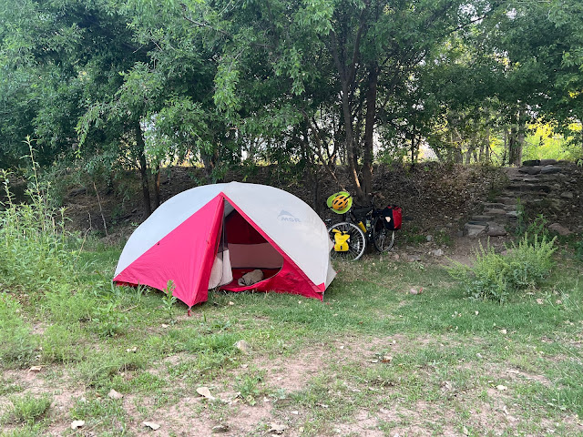
By 7:15 PM the temperature had once again become reasonable. The sun went over the horizon at 7:25 PM. The nearly full moon was visible to the east. It would be full tomorrow. After eighty miles I noticed a long gravel road, and I pulled off the highway. I pedaled away from the roadway and eventually noticed some beehives in the distance. I erected my tent on a hillside scattered with rocks. The wind out of the west was strong making tent set-up a challenge.
 |
| Room # 241 at the Hampton Inn Biltmore in Phoenix |
 |
| This was a good year for gold panning because of the rain storms. |
 | ||
Wickenburg, AZ
|

 |
| Sunset from my campsite |
 |
| Map / Elevation Profile |

Comments
Post a Comment